Showing posts with label GIS. Show all posts

Wednesday, July 13, 2011

Export KML from Google Maps

You know, Google Maps support KML. It means much of the content you create or get in Google Maps can be exported to kml files and be viewed in Google Earth.
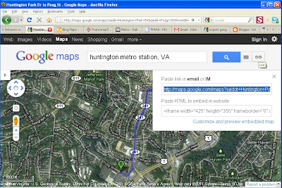
You can follow the following steps to get the kml file of a route generated in Google Maps.

(1) Left Click "Link" and copy
the link to the clipboard:


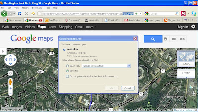
(2) Paste the link into the address bar and then ADD "&output=kml"at the end of the original link.
Press "Enter". You will see a pop up window asking you if you want to "Open" or "Save" the kml file.


Tuesday, February 22, 2011

How to split a polygon by an overlapping line feature

Here is a tip to split a polygon by an overlapping line feature. I have tested it in ArcMap 9.3 and it works.

http://webhelp.esri.com/arcgiSDEsktop/9.3/index.cfm?TopicName=Common_polygon_editing_tasks

· Select the polygon.

· Set the task to Cut Polygon Features.

· Click the Sketch tool.

· Right-click the line and click Replace Sketch. This lets you see the line's vertices and segments as an edit sketch.

· Finish the sketch (you can press F2 so you don't inadvertently add more segments to the sketch when you finish it). The polygon is split where the line crosses it.

Tuesday, August 31, 2010

A kml to shapefile converter

Tool: FWTools
Download link: http://fwtools.maptools.org/

At the command line prompt, use the following syntax
Syntax:
Ogr2ogr -f “ESRI Shapefile”

Example 1:
To convert sample.kml located in C:\Test and save the converted shapefile in the same folder,
C:\>Ogr2ogr -f “ESRI Shapefile” C:\Test\sample.shp C:\Test\sample.kml


Things to remember:
1. Only KML files can be converted to *.shp. If the file is in KMZ format, save as “KML” before conversion.
2. The KML file name should not contain white spaces. The best practice is to use “_” or “-“ as separators instead of a space.
3. The coordination system of the shapefiles may need to be changed because Google Earth's native coordination system is
• Geographic Coordinates (latitude/longitude) GCS_WGS_1984
• Datum: D_WGS_1984

Free GIS application

MapWindow GIS Application

http://www.mapwindow.org/download.php?show_details=1

Description:

MapWindow GIS desktop application is a free, open source, standards-based standalone software package that you can use to view and edit GIS data in many file formats.

The software includes plug-ins for various geoprocessing tasks (e.g. buffer, merge, etc.), watershed delineation, accessing online data sources, and an experimental geodatabase plug-in. The attribute table editor can be used to write simple queries, and there is a complete scripting editor that allows you to write and run scripts in VB.NET and C# directly in the MapWindow program.

Download MapWindow GIS if you need a simple map viewer, or if you want to write your own custom plug-ins to distribute to other users.

The installer includes sample data and is compatible with Windows 98 and up. Source code can be downloaded using SVN code repository.

My Comment:

I really like those plug-in tools.
For example, the coordination system converter is really convenient!
From that GIS Tools menu, select Vector => Reproject a Shapefile.
Monday, January 25, 2010

GIS Data

VA:
http://www.virginiaplaces.org/boundaries/gisdata.html
http://gisdata.virginia.gov/Portal/

MD:
http://www.marylandgis.net/SHAdata/

MA:
http://www.mass.gov/mgis/laylist.htm

Other regions:
http://seamless.usgs.gov/
http://arcdata.esri.com/data/tiger2000/tiger_download.cfm
http://data.geocomm.com/catalog/index.html
http://www.nationalatlas.gov/atlasftp.html
http://gisdata.virginia.gov/Portal/

Scripts for ESRI software:
http://arcscripts.esri.com/

Freeware (Forestry GIS)
http://www.forestpal.com/fgis.html